
Save Top Field
LATES NEWS
On 27 February Lidl sent in a crew with a JCB to test the subsoil on Top Field. They chose a week when the field was saturated and left a terrible mess. There has been no North Lincs Council planning meeting to discuss their own development plan and no plan has been submitted by Lidl. It is hoped that the field will be restored to its former condition as soon as weather conditions allow and at no cost to Council Tax payers.
 |
WHERE IS IT?
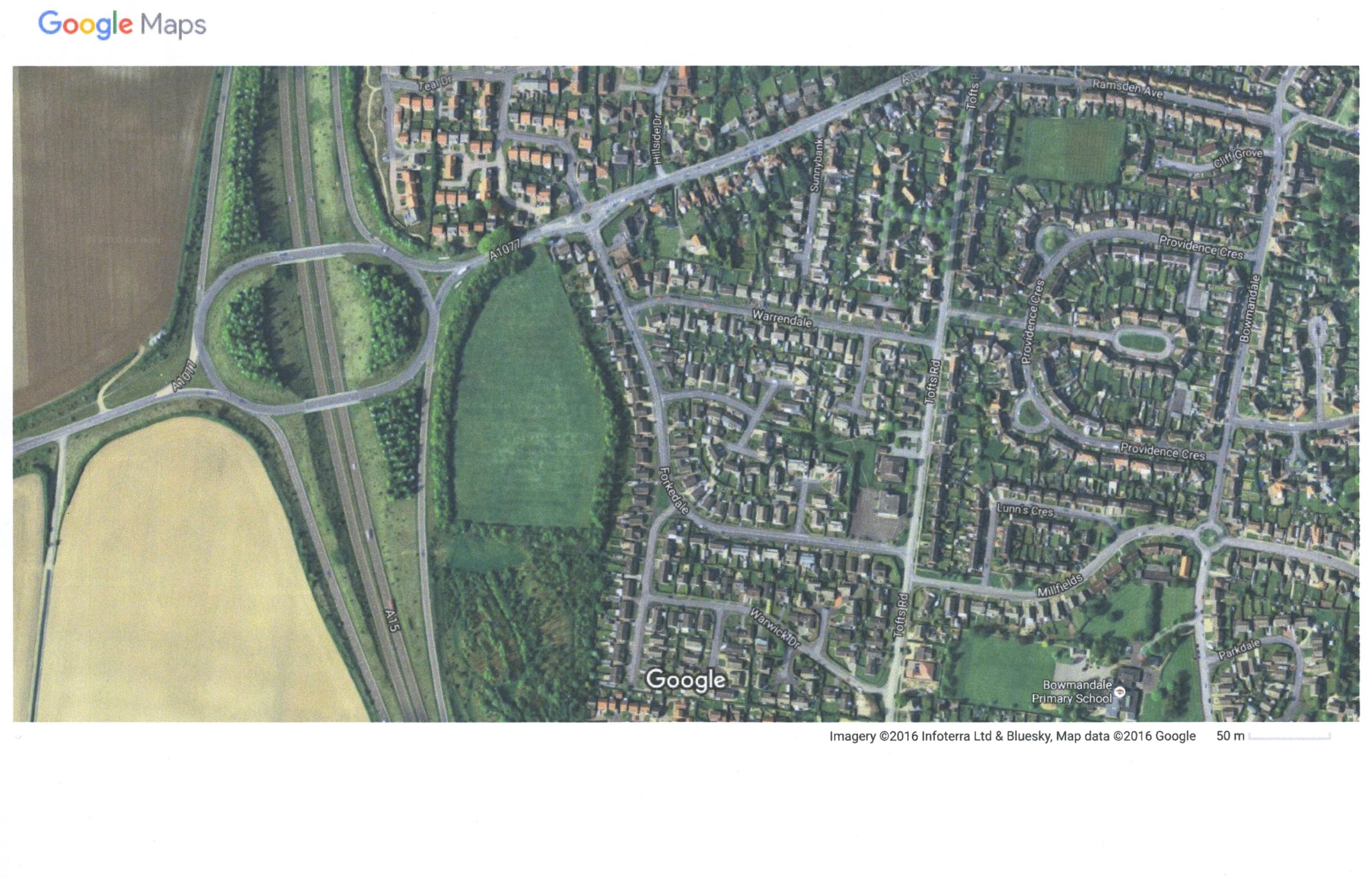
Top Field is the 7 acre grass field between the Forkedale/Feyzin Drive
roundabout on the south side – left hand as you drive up the hill. It has been a
green space since about 1982 when it was designated a buffer zone to shield
houses from the noise predicted to get worse after the opening of the Humber
Bridge. It was bought initially by Glanford Borough Council and is now owned by
North Lincolnshire Council
|
NORTH
LINCOLNSHIRE COUNCIL OUTLINE PLAN PRESENTED AT THE PUBLIC MEETING |
 |
|
This is the outline plan that North Lincolnshire Council has come up
with. It beggars belief that anyone can imagine an entrance to a busy
site between the two roundabouts. Any of us who ever drive up Ferriby
Road can see a death trap here.
Oh, and it seems they forgot to provide us a walk through the estate
to the woods… |
 |
|
This
Google photograph clearly shows the access between the two roundabouts.
It also shows the wood to the south, which is not under threat at the
moment.
|
WHAT IS GOING ON?
Presumably to raise capital funds and to save grass cutting costs, North Lincs
Council would like to see a supermarket, a family pub and 70 houses built on Top
Field. The outline plan shows access off Ferriby Road between the roundabouts
and most of the houses aligned with the south-bound slip road.
WHY IS IT WRONG?
1.
This is a well-used and much appreciated green space which greatly
enhances the approach to the town. The Tourism Partnership is working hard to
establish Barton as a tourist destination and the attractive, semi-rural nature
of the entrance to the town, distinguishes it from other places where out of
town development leads to a bland uniformity. More importantly, this is also the
only open and accessible green space at this side of the town and it should be
retained to in order to encourage exercise and an enjoyment of nature, both of
which are recognised as vital to health and well-being.
2.
This area was originally designated as a buffer zone to shield houses
from noise from the A15. Increased traffic in the last thirty years has surely
made this even more necessary, particularly as the indicative plan shows houses
located very close to the boundary with the A15. The loss of the linear shelter
belt of trees will also destroy the north/south wildlife corridor which
currently exists and provides an important and diverse natural habitat.
3.
In common with many other communities Barton Town Centre is struggling,
retail premises are standing empty, two public houses have recently closed and
at least two others are up for sale. The town is already more than adequately
served by major name supermarkets and any out of town development would drain
even more of the life from the town centre.
4.
The infrastructure of the town is already struggling to provide services
for the existing level of population, the nearest primary school to this site is
Bowmandale which is already full and any further development would increase
pressure on all the local schools. Similarly the current doctors and dental
surgeries are at full capacity. Before any further development takes place in
the town these issues should be addressed.
5.
Access and egress to this site is problematic as the planned entrance to
the site is from a short stretch of road between two roundabouts. Ferriby Road
is the only approach road into Barton from the A15 and is used by the majority
of commercial traffic from all directions.
This very busy thoroughfare is already congested at peak times and any
commercial or private vehicle would have extreme difficulty turning into this
site without causing major traffic delays. It would also appear that residents,
shoppers, delivery vehicles and visitors to the public house will all access the
site via the same single entrance. This would create a very dangerous situation
for both drivers and pedestrians. Added to this, residents on the east side of
the town and those from the main catchment villages, also predominantly to the
east of the town, will need to drive through the Market Place and up Ferriby
Road creating yet more traffic hazards and air pollution.
We do not feel sufficient, if any, consideration has been given these
aspects of the proposal.
HOW CAN WE STOP THIS DEVELOPMENT?
If all those of us who think it is a bad idea object to the outline plan, then
perhaps North Lincs Council will look elsewhere to raise the money they need, so
PLEASE, go on the website and OBJECT.
www.northlincs.gov.uk/planning
will get you on the North Lincs planning pages, then go to planning application
number PA/2016/1490 and list your objections.
LAST DATE to object is 27 October, so please hurry.
WHAT ELSE CAN WE DO?
Talk to friends and neighbours to make sure they know about the proposals and
can have their say. Write to our MP, Martin Vickers, and let him know what you
think. Use social media to spread the word – we can stop this development, it is
up to us!
GET IN TOUCH
Let us know what you think – please get in touch at
savetopfield@gmx.com
|
Copyright 2016 Barton upon Humber Civic
Society and www.inbarton.co.uk. |